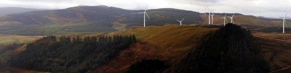
The seat with the view (as seen by Googe Street View). At Tairlaw, just at the entry to the Galloway Forest, with a lovely view of Genoch Inner Hill and Back Fell behind, and who knows, in a couple of years’ time, about 35 125m turbines… Below you will find a gallery of images which show views which will be critically affected by the proposals. If you wish to use these images please do, with appropriate credits, and for non-commercial use. If you wish to add any, or if you require annotation or information about where they were taken from, please contact us using the form on the Contact page. There are also some photomontages of the proposed windfarm site at Linfairn. Below this again, a second gallery of composite photos of particularly beautiful viewpoints around Straiton. Below that, a gallery of images of Whitelee Wind Farm taken in June 2013. 
-

-
photo C Craig
-

-
photo C Craig
-

-
photo C Craig
-

-
photo C Craig
-

-
photo C Craig
-

-
composite photo J Meuli
-

-
photo J Meuli
-

-
photo Bea Holden
-

-
photo J Meuli
-

-
photo J Meuli
-

-
photo Bea Holden
-

-
photo M&A Hogg – Geograph website
-

-
photo Carol Watt
-

-
photo Carol Watt
-

-
photo Carol Watt
-

-
photo J Meuli
-

-
photo J Meuli
-

-
photo Billy McCrorie – Geograph website
-

-
photo M&A Hogg – Geograph website
-

-
photo Philip Jeffrey – Geograph website
-

-
photo J Meuli
-

-
photo J Meuli
-

-
photo J Meuli
-

-
photo J Meuli
-

-
photo Eddie O’Gorman
-

-
photo Eddie O’Gorman
Back to top
Photomontages
Most people in and around Straiton are opposed to the windfarms, because they will completely dominate a landscape which is very attractive, much visited, and which is the base of a small but growing tourist economy. If you click on the images below, which are montages by WilloWind, you will perhaps see why there is opposition.

View from Monument hill back up the Girvan valley towards the Galloway Hills. Genoch Inner Hill at the left, Balbeg and other houses to the right.
from the same point as the photograph above, looking towards Bennan hill and wood.

from the churchyard up towards Bennan Hill
The next picture, below, shows the view from Bennan Hill up towards the Galloway Hills, with Shalloch-on-Minnoch prominent, and Cornish Hill and Merrick also visible. It shows how Straiton really does stand at the gateway to the Galloway Forest. Under the new windfarm proposals, the middle distance of this photograph would be occupied by around twenty 100 to 125m turbines, with a further 28 turbines to the right of the photograph. The Galloway hills would be almost hidden in this view. 
Below are some images, not by WilloWind but by campaign-supporter Malcolm Kirk. The first shows the likely impact on the view from the old track to Patna. (Nb. it shows only a part of the proposed Linfairn wind farm: and it doesn’t show the 19 turbines of the proposed Dalmorton wind farm, which would also be visible on the slopes of Back Fell, behind the Linfairn turbines). The second image is a wireframe view of the visibility from Straiton village. These views, like those from WilloWind, still use the turbine layout proposed in February 2013 – we are still awaiting the new layout.

image: Malcolm Kirk

image: Malcolm Kirk
Back to top
Composite Photographs

looking northwest – Craigengower and the monument to the right, Sclenteuch forest to the left. © Jonathan Meuli : 75mm lens : from from the summit of Bennan Hill : NS 37913 03374: 13th March 2013 : part 1 of 360° panorama

looking ESE – Doonan’s hill in foreground centre, with Big Hill of the Baing behind it. Centre distance, the big snow-cap of Cairnsmore of Carsphairn. © Jonathan Meuli : 75mm lens : from from the summit of Bennan Hill : NS 37913 03374: 13th March 2013 : part 2 of 360° panorama

looking SSE – steep Craig Hill in sunshine to the left foreground (snowy summits of Coran of Portmark and Meaul in the distance behind. Left centre: the rocky slopes of Genoch Inner Hill (in shadow – middle distance). To the right of Genoch Inner Hill, the cleft pyramid of Cornish Hill, and then (moving right) the snowy summit of Merrick, and the big bulk of Shalloch on Minnoch to the right. In the foreground, down a little from Shalloch on Minnoch, is Linfairn farm, surely one of the most beautifully situated farms in Scotland. © Jonathan Meuli : 75mm lens : from from the summit of Bennan Hill : NS 37913 03374: 13th March 2013 : part 3 of 360° panorama

Looking SW (and into the sun). The forested slopes up past Knockskae (Balbeg burn hidden by the foreground of Bennan Hill). Just visible, to the right hand side, the top of Back Fell (Glenalla Fell) – whose beautiful conical shape overlooks the path from Patna to Barr – and a quiet wilderness which is home to much wildlife. © Jonathan Meuli : 75mm lens : from from the summit of Bennan Hill : NS 37913 03374: 13th March 2013 : part 4 of 360° panorama

looking due West – the unmistakeable forms of Black Hill of Knockgardner and Green Hill of Knockgardner, and between them, in the blue distance, Ailsa Craig. © Jonathan Meuli : 75mm lens : from from the summit of Bennan Hill : NS 37913 03374: 13th March 2013 : part 5 of 360° panorama

looking WNW over the woods of the Blairquhan estate: Arran and Goat Fell, (centre left distance), Maybole: and then Ayr, Irvine, Argyll, and the distant snows of the highlands. © Jonathan Meuli : 75mm lens : from from the summit of Bennan Hill : NS 37913 03374: 13th March 2013 : part 6 of 360° panorama

Looking south into the heart of the Galloway Forest Park, with Genoch Inner Hill and Linfairn farm in the middle distance. © Jonathan Meuli : 17.5mm lens : from from the summit of Bennan Hill : NS 37888 02876: 13th March 2013

looking from near the turn to Altizourie, on the B7045. The fringes of Sclenteuch forest just visible above the pasture to the left of the road: Monument hill just beginning to the right in the distance. © Jonathan Meuli : 75mm lens : from NS 37288 06501: 13th March 2013 : part 1 of 180° panorama

looking from near the turn to Altizourie, on the B7045. Bennan Hill on the right and the Monument Hill (Craigengower) on the left frame the entry into the upper Girvan valley, where the Newton Stewart road leads up into the Galloway Forest. Straiton lies hidden at the foot of these two hills. © Jonathan Meuli : 75mm lens : from NS 37288 06501: 13th March 2013 : part 2 of 180° panorama

looking from near the turn to Altizourie, on the B7045. The tower of Blairquhan castle visible to the right. In the background, Green Hill of Knockgardner and Black Hill of Knockgardner. © Jonathan Meuli : 75mm lens : from NS 37288 06501: 13th March 2013 : part 3 of 180° panorama

The beautiful conservation village of Straiton, lying between Craigengower and Bennan hill, as you arrive on the B7045 from Kirkmichael. ©Jonathan Meuli : 75mm lens : from NS 37820 05249: 13th March 2013 : approx 110° panorama

Straiton seen from the bridge over the Water of Girvan on the B741 (Dailly/Crosshill road). Monument hill behind the trees. ©Jonathan Meuli : 75mm lens : from NS 37695 04969: 13th March 2013 : approx 160° panorama

Straiton seen from the bridge over the Water of Girvan on the B741 (Dailly/Crosshill road). Forested Bennan hill left centre and extening to the right. ©Jonathan Meuli : 75mm lens : from NS 37695 04969: 13th March 2013 : approx 160° panorama

Straiton seen from junction of two paths: the old track to Patna, and the path to Altizourie. Largs Hill and Monument Hill dominate the view to the southeast. ©Jonathan Meuli : 75mm lens : from NS 38900 06013: 13th March 2013 : part 1 of approx 160° panorama

Straiton seen from junction of two paths: the old track to Patna, and the path to Altizourie. Looking SW, you can see wooded Bennan hill in the centre. To its left, the Girvan valley goes up into the Galloway forest, past Linfairn, visible on the far side of the valley. Centre right, the white houses of Straiton, with Back Fell in the distance above. To the right, Green and Black Hill of Knockgardner. ©Jonathan Meuli : 75mm lens : from NS 38900 06013: 13th March 2013 : part 2 of approx 160° panorama

The Girvan valley, seen from the driveway to Genoch farm. On the left, Genoch farm in its beautiful setting amidst the trees. Just to the right of the trees, you can see Genoch cottage in the background. Above the houses, the rocky outcrops of Genoch inner hill. Moving right, we come to the lower slopes of Knockronal and Big Benyaw. Notice the roofless shape of High Genoch, abandond for some decades now. To the right, notice also the beautiful S-shapes of the old stone dykes. ©Jonathan Meuli : from NS 38994 01265: 1st April 2013 : part 1 of a two-part approx 180° panorama

The Girvan valley, seen from the driveway to Genoch farm. Centre left, seemingly on its own eminence, but actually on a continuous slope, Linfairn farm amidst trees and blue metal barns. Behind, the forested slopes of Knockskae, and just visible, the treeless mountain peak shape of Back Fell. To the right of Linfairn, the line of trees marks the drive up to the farm, and then the location of hidden Palmullan burn in its secretive gorge. To the right again, the lovely smooth undulating curves of Dalmorton Hill: on its left in the far distance, the Black Hill of Knockgardner, and to its right, the beginnings of Cawin Hill. ©Jonathan Meuli : from NS 38994 01265: 1st April 2013 : part 2 of a two-part approx 180° panorama

The view from the field just below Knockskae. To the left the familiar lines of Monument Hill. Moving right, centre image, sunlit, the uneven domes of Knockscawin and the Doonans. Then a marvellous view of the crags and scree slopes of the west face of Craig Hill, where the Wild Things Are (well, peregrines for a start). ©Jonathan Meuli : from NS 37380 01540: 1st April 2013 : part 1 of a 3-part approx 180° panorama

The view from the field just below Knockskae. Starting at the left, the right hand side of Craig Hill where it slopes down into Glengill Hill. Then the shoulder of the Big Hill of the Baing, and snow-covered in the distance, the Big Hill of Glenmount. To the right, the forest snakes up the slopes above Tairlaw. Below, in the middle distance, the barns of Linfairn farm. Then, rocky and covered in snow patches, is Genoch Inner Hill in the weak Spring sunshine. Finally, to the right, the beginnings of the slopes of Big Benyaw. ©Jonathan Meuli : from NS 37380 01540: 1st April 2013 : part 2 of a 3-part approx 180° panorama

The view from the field just below Knockskae. The slopes of Big Benyaw and Knockcronal. If you look at the photo at full size and zoom in on the middle panel of the composite, you can see the meteorological mast for Linfairn wind farm, one of four windfarms which will completely dominate this landscape in an almost complete 360 degree circle, if built. ©Jonathan Meuli : from NS 37380 01540: 1st April 2013 : part 3 of a 3-part approx 180° panorama
Back to top
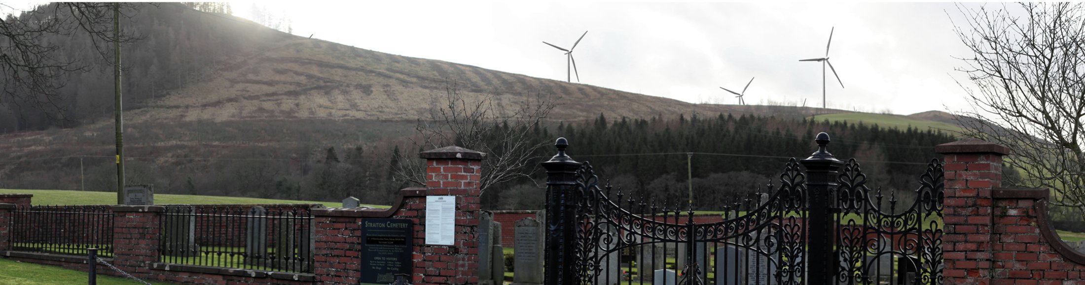
Some shots of Whitelee windfarm – 9th June, 2013, by Jonathan Meuli. The turbines photographed are 110m high – those planned for the wind farms around Straiton range from 110 to 150m high.
Back to top


All of these developments will virtually be meeting the proposed extension to Hadyard Hill. There are 2 wind masts that SSE have erected to monitor for more turbines. There is talk of a further 88 turbines.
I predict that in some future day when the truth is finally out and these white “elephants” are finally recognised as such, and all govt subsidies are withdrawn, that they will fall silent. And then without said subsidies, no-one will be interested in removing them. Thus our landscape will be littered with relics from a man made folly of widespread proportions! Like an abandoned battlefield of robotic monsters! Pessimistic, yes. Prophetic, probably!
Think you could safely say that this beautiful area has been desecrated by these huge white elephants – and yet the developers and the SNP still want to construct more wind farms. They do absolutely nothing to reduce emissions. It’s a crime. I agree with Les Cairns.
Last year (1016) my wife and I paid a visit to Straiton and surrounding area with the view to buying property and settling in this beautiful part of the country. We were shocked to find the countryside littered with these monstrous monuments to the energy industry. What a blight and scar. As we considered other areas, we decided to “GOOGLE” wind farms in Dumfries & Galloway and found to our dismay there is hardly an area not affected by wind turbines. Looking further afield, there hardly an area of Scotland not affected by wind turbines unless we move to the peripheries of a large town. Perplexed!
My date should have read 2016 and not 1016. That would make us very old indeed!